Friday, May 3, 2013
Heading North Very Soon - 2013 Plans
We are both very excited about our 2013 PNW boating plans. Unlike our adventures in 2005 and 2008, we'll be cruising with a more flexible schedule. We know we want to spend more time cruising in the Broughtons than we have previously. We'll then decide if we head back north to SE Alaska or spend the summer in northern BC.
Stay tuned.
Journey's End of our 2008 Cruise, from the Skipper

As the skipper of El Bucanero, I was tasked with both keeping us safe and keeping the boat out of harm’s way. This was constantly on my mind until the boat arrived back in San Diego and was put in the water in Mission Bay, San Diego. We traveled over 2,400 miles on the boat his summer so one has to be prepared to deal with ‘issues’ as they arise.
There were challenging times: in the category of boat operation, the alternator did not charge the house batteries from Anacortes to Petersburg, Alaska. Our primary battery charger/inverter stopped working by the time we got to Ketchikan. We had an aged charger on board so that was put to work. My skills as a mariner were tested as well. We often had to make passages in very limited visibility conditions – very heavy fog and rain. Or being on anchor with gale force winds blowing made for sleepless nights. This coupled with sea conditions and debris in the water (logs, deadheads, etc.) made for challenging times.
I think what I will remember most about our adventure this summer was the remoteness of Alaska- the natural beauty and wildlife, as well as the people we met in the course of our voyage. The experience of sharing dock space at Warm Springs on Baranof Island with commercial salmon seiners won’t soon be forgotten. Waking early one morning and watching brown bears not 30 ft. away from our boat go about digging for clams at Pack Creek, Admiralty Island, was very special.
It was truly and experience of a lifetime for Darlene and I. We will never have to think back at some time in our lives and say, “If we only went to Alaska when we could have..”
There are no guarantees in life and we did indeed experience some things that were very special that we will remember the rest of our lives.


Summary Itinerary
Here is a quick posting to provide a summary view of our PNW 2008 Cruise Itinerary.
0516 – boat departed MBYC
0516 – spent the night at home, in San Diego
0517 – departed home, spent the night in Redding, CA
0518 – Anacortes, WA
0519 – “ “
0520 – “ “
0521 – “ “
0522 – “ “
0523 – “ “
0524 – “ “
0525 –Anacortes to Blind Bay, Shawl Island
0526 – Blind Bay to Prevost Harbor, Stuart Island
0527 – Prevost Harbor to Tseshum Harbor, Vancouver Island, BC
0528 –Nanaimo, Vancouver Island, BC
0529 – Comox, Vancouver Island, BC
0530 – Campbell River, Vancouver, Island, BC
0531 “ “ “ “ “
0601 _ Shoal Bay, East Thurlow Island, BC
0602 _ Port Neville, BC
0603 – Lagoon Cove, The Broughtons, BC
0604 – Lagoon Cove to Port McNeill, BC
note: I need to reconcile my notes to our log, as I believe we spent 3 nights in Port McNeill due to Gale Winds
0605 – to Allison (30.7 nm) (stay over an extra night due to gale winds)
0608 – layover in Allison
0609 – Allison to Green Island (47.5 nm)
0610 – Green Island to Shearwater, BC (40 nm)
0611 – Shearwater to Bottleneck Inlet, BC (52 nm)
0612 – Bottleneck Inlet to Khutze, BC (29 nm)
0613 – Hartley Bay, BC
0614 –Kermelean Cove, BC
0615 –Prince Rupert, BC (33 nm)
0616 –Foggy Bay, Misty Fiords National Monument Wilderness, Alaska (39 nm)
0617 –Ketchikan, Alaska
0618 – “
0619 – “
0620 – “
0621 – Ketchikan to Meyers Chuck, Alaska
0622 – Santa Anna Inlet, Alaska
0623 – Wrangell, Alaska
0624 – “ “
0625 – Petersburg, Alaska
0626 – “ “
0627 – “ “
0628 – Snug Harbor, Gambier Bay, Admiralty Island
0629 – Windfall Harbor (Pack Creek), Admiralty Island
0630 – Hobart Bay, Alaska
0701 – Petersburg, Alaska (our cell phone died so we returned to Petersburg to wait for arrival of a FedEx pkg, for a replacement phone)
0702 – " "
0703 – " "
0704 – " "
0705 - Pybus Bay, Admiralty Island (52 nm)
0706 - Warm Springs, Baranoff Island (35 nm)
0707 - Appleton, Baranoff Island (40 nm)
0708 - Baby Bear Marine Park, Baranoff Island (22)
0709 - Sitka, Baranoff Island (29 nm)
0710 – “ “
0711 – “ “
0712 - Baby Bear, Baranoff Island (29 nm)
0713 - Appleton (21.8 nm)
0714 - Warm Springs (39 nm)
0715 - Petersburg (72 nm)
0716 “
0717 - Wrangell (40 nm)
0718 - Frosty Bay (32 nm)
0719 “ “
0720 – Meyers Chuck
0721 – Meyers Chuck
0722 - Ketchikan (lengthy stay in Ketchikan due to Gale/Storm Winds)
0723 – "
0724 – "
0725 – "
0726 – "
0727 – "
0728 – Ketchikan to Foggy Bay, Alaska
0801 – Foggy Bay, Alaska to Prince Rupert, BC
0802 – Prince Rupert to Klewnuggit
0803 – Klewnuggit to Hartley Bay
0804 – Hartley Bay to Khutze Inlet
0805 – Khutze Inlet to Rescue Bay
0806 – Rescue Cove to Codville Lagoon
0807 – Codville Lagoon to Fury Cove, Penrose Island
0808 – Fury Cove, Penrose Island to Blunden Harbor
0809 – Blunden Harbor to Jennis Bay
0810 – Jennis Bay to Sullivan Bay
0811 – Sullivan Bay to Shawl Bay
0812 – Shawl Bay to Echo Bay
0813 – Echo Bay to Kwatsi Bay
0814 – Kwatsi Bay to Lagoon Cove
0815 - Lagoon Cove, The Broughtons, to Forward Harbor
0816 – Octopus Islands, BC
0817 – “ “ “
0818 – “ “ “
0819 – Squirrel Cove
0820 –
0821 – Pender Harbor
0822 – Nanaimo
0823 – “
0824 – “
0825 – “
0826 – Newcastle Island
0827 – Maple Bay (MBYC), Vancouver Island
0828 – “ “ “ “ “
0829 – Ganges, Salt Spring Island
0830 – “ “ “ “
0831 – Lyall Harbor, Saturna Island
0901 – Prevost Harbor, Stuart Island
0902 – Roche Harbor, San Juan Island
0903 – Garrison Harbor, San Juan Island
0904 – Jones Island (77 nm)
0905 – Blind Bay, Shawl Island (6.1 nm)
0906 – Anacortes, Fidalgo Island, Wa
0907 – “ “ “
0908 – “ “ “
0909 - EB was hauled out in Anacortes, WA. We spent the night in
Grants Pass, Oregon.
0910 – We spent the night in LeBec, CA
0911 – We arrived home and were able to sleep in our own bed.
Friday, September 12, 2008
El Bucanero is back home
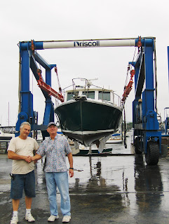
El Bucanero arrived in San Diego last night. She spent the night on Wave Maker's trailer, near Driscoll's Boatyard in Mission Bay. This morning (Fri) she was launched and is now back at her home port slip at MBYC (Mission Bay Yacht Club).
Our focus is now on cleanup of our adventure. We also have many wonderful memories that we will treasure forever, along with insights to help plan future trips.
We are planning to have a slide show presentation on our adventure at MBYC in Jan' 08, where we can share our insights on cruising the PNW. If you are interested in joining us, please let us know and we'll ensure you are aware of the final date & timing.


Tuesday, September 9, 2008
Homeward Bound!
We spent last night of our trip on El Bucanero, in the Cap Sante Marina,in Anacortes, WA. We were located where the travel lift is. While this was a unique place to spend the night, we did have a great sunset. And, we had a better night's sleep as we didn't have to worry about moving the boat very early this morning. For the most part, everything was secured last night, but we did have quite a few things in the cockpit area, which we couldn't move inside until this morning. It made things tight for Brad to BBQ last night, but it worked better than if we had remain in our original slip in Cap Sante Marina.
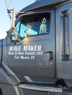
Here is a photo of our very dirty, but beloved boat being hauled out.

Jimmy, from WaveMaker is tranporting our boat back to San Diego. And Jimmy has a new four legged friend to keep him company on his journey. His two four legged children, which accompanied him on the ride to get is from San Diego to Anacortes, are now back home keeping Jimmy's wife company.
It will take us almost 3 days to get back to San Diego. We're spending the night in Grants Pass, Oregon, which is a beautiful place that we'd love to come back to explore. Looks like a great place to hike, kayak and simply explore a beautiful town!
Here is a photo of our very dirty, but beloved boat being hauled out.

Jimmy, from WaveMaker is tranporting our boat back to San Diego. And Jimmy has a new four legged friend to keep him company on his journey. His two four legged children, which accompanied him on the ride to get is from San Diego to Anacortes, are now back home keeping Jimmy's wife company.

It will take us almost 3 days to get back to San Diego. We're spending the night in Grants Pass, Oregon, which is a beautiful place that we'd love to come back to explore. Looks like a great place to hike, kayak and simply explore a beautiful town!
Sunday, September 7, 2008
Having fun in Anacortes,WA

While we were doing some work, to prepare our boat for transport, a cute harbor seal decided to sun itself on a nearby finger of the dock. Usually the PNW seals are so allusive I'm not fast enough to snap a picture, but while this cute guy let me take a picture, he was still quite shy...and jumped into the water shortly after this shot.
We also had fun watching a harbor seal swim on his back, tummy up to the sunshine, looking like he wanted to be a sea otter. Unfortunately, I wasn't fast enough with a camera for that pose.
It was another perfectly sunny day in Anacortes today. Clear skies and sunshine from the start of the day till the end, with a few pink clouds at sunset. {and no rain all day}.
Saturday, September 6, 2008
PNW Journey has ended
We completed our last leg of our cruise, on the water, when we tied up at the Cap Santa Marina in Anacortes. Our arrival was at 9:45am, which gave us plenty of time to start preparing the boat for truck transportation back to
Our current position is: 48 30.803N 122 36.300W
While I hope to get back online by Monday evening, to upload some photos, here is a short insight on what we've been up to since my last posting.
September lst - Lyall Harbor to Prevost Harbor, Stuart Island, San Juan Islands (9.3 nm)
A photo taken during our our morning cruise.

Prevost Harbor


September 2nd - Prevost Harbor to Roche Harbor, San Juan Island (6.9 nm)
While on our morning cruise, when we left Prevost Harbor we pass by Johns Island. There is a large collection of teepees, which we passed. I recall seeing a smaller number of these teepees in 2005. I'm curious as to what is going on. Is this a kids' camp? Can anyone come? Is there an indian tribe that is growing? If anyone knows what is going on here, please let me know. Curious minds want to know. I counted about 75+ teepees, but not certain how many are actually there.

A thistle in the flower gardens of Roche Harbor. Does this prove this is a flower vs a weed? I've always loved the thistle, which we do not see in So. Cal. But I know many of my PNW friends view the thistle as an invasive weed.


We enjoyed our walk to the Mausoleum. We saw a large fox, while we were on our walk. And upon our arrival, there was a young deer eating grass next to the Mausoleum.


September 3rd - Roche Harbor to Garrison Harbor, San Juan Island (2.2 nm)
Garrison Harbor is the site where the English had a camp in the mid-1800s. An American Camp was set up on another side of the island. The two military forces were involved in a political war, each claiming ownership over the island. Aka "Pig Wars". While it is now an historic site, it is a great place for boaters to visit by water (and you can also visit by car). There is a lovely hiking trail, to the top of the mountain, which gives you a nice view to Victoria, Vancouver Island and to other others in the San Juans and Gulf Islands. It is one of our favorite hikes in the San Juans!


There is also a beautiful flower garden at Garrison Bay.


This photo doesn't really capture the beauty of the area, which can be viewed by taking the hike to the top of the mountain. It is definitely worth the hike!

September 4th - Garrison Harbor to Jones Island (7.7 nm)


September 5th - Jones Island to Blind Bay, Shaw Island (6.1 nm)
September 6th - Blind Bay to Anacortes, Fidalgo Island (16.5 nm)


Subscribe to:
Comments (Atom)


